
Lake Powell and Lake Mead: Water and Power Crisis
This post may contain affiliate links. We may earn a commission if you purchase via our links. See the disclosure page for more info.

Lake Powell and Lake Mead: Water and Power Crisis. Friends, if you’ve ever driven past Lake Powell or Lake Mead and noticed that white bathtub ring circling the shoreline, you’ve already seen the story with your own eyes. Our two largest reservoirs in the country are shrinking, and what happens to them touches nearly everyone west of the Mississippi, whether you live near the Colorado River or simply flip a light switch every evening. Today I want to walk you through what’s happening, why it matters for your family, and what the future may hold. As always, I’ll keep this practical and hopeful, because that’s how we do things around here. Please store water: WaterBricks
Lake Powell and Lake Mead: Water and Power Crisis
A little history first
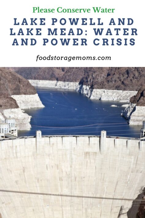
To understand why this moment feels so significant, it helps to know a bit about how these lakes came to be. Hoover Dam was completed in 1935, holding back the Colorado River to form Lake Mead, the largest reservoir in the country by volume. Glen Canyon Dam followed decades later, finished in 1963, creating Lake Powell just upstream. Together these two structures were built to store water during wet years so there would be enough to go around during dry ones, and to generate clean hydroelectric power for millions of homes across the Southwest.
For most of their history, these lakes have risen and fallen with the seasons, but they’ve never both been full at the same time since 1983. Since then, growing populations, expanding farmland, and a warmer climate have slowly tipped the balance, and the last twenty-five years in particular have been unusually dry across the entire Colorado River basin.
Where the water levels stand right now
As of this month, Lake Powell is currently only 23 percent full, its lowest level on record for July. Lake Mead isn’t far behind, sitting at about 27 percent full and less than a foot from its all-time record low set in 2022. Together, these two reservoirs haven’t been this low since 1957, back when Glen Canyon Dam was still under construction, and Lake Powell didn’t even exist.
Experts tracking the system say Lake Powell and Lake Mead are likely to set a new record low for their combined water storage nearly every day between now and next spring, when winter snowmelt finally begins to trickle back into the system. Lake Powell sits about thirty-three feet above the elevation known as power pool, and Lake Mead is measuring below the Tier 1 shortage threshold that triggers mandatory water cutbacks for several states.
Why the water keeps dropping
The short answer is drought and demand. The Colorado River has shrunk rapidly over the past twenty-five years as water demand has grown and a warmer, drier climate has reduced snowpack. Right now, roughly ninety-five percent of the river basin is in drought.
This past winter brought a snow drought across much of the West. Snowpack in the mountains that feed the Colorado River peaked well below normal, and the spring runoff that normally refills these lakes between April and July was one of the lowest ever measured, only a small fraction of the long-term average.
It’s worth remembering that this river was divided up nearly a century ago based on measurements taken during an unusually wet period. In other words, the water rights on paper have always promised more water than the river reliably provides, and now that gap is showing up in the lake levels themselves.
Why hydropower is at risk
This is the part that surprises a lot of folks. These reservoirs are not just water supplies; they’re also power plants. Glen Canyon Dam, which holds back Lake Powell, generates hydroelectric power sold to utilities and rural electric cooperatives across the Southwest, powering millions of homes and businesses.
There’s a specific elevation called minimum power pool, sometimes nicknamed dead power pool. This’s the point where the water level drops too low to spin the turbines, meaning the dam can no longer produce hydropower at all. That threshold sits at 3,490 feet of elevation. Below that is an even lower point called dead pool, where water can no longer even pass through the dam, which would have serious consequences for everything downstream, including the Grand Canyon ecosystem.
Hoover Dam faces a similar concern further downstream on Lake Mead, though it currently has a bit more cushion. Still, Lake Mead is below the Tier 1 shortage level that already triggers mandatory water use reductions for Arizona, Nevada, and parts of Mexico.
If either dam were to lose the ability to generate power, that electricity has to be replaced somehow, likely through more expensive and less clean sources purchased on the open market. That could mean higher utility bills for families across several states, not just here in the interior West, since hydropower from these dams is woven into regional power grids far beyond the immediate area.
Who’s affected?
This isn’t only a Western issue. The Colorado River system provides water and power for roughly forty million people across seven states, plus parts of Mexico, along with a large share of the country’s winter vegetable crops. If you’ve ever eaten lettuce, broccoli, or almonds in January, there’s a good chance the Colorado River had something to do with it.
Locally, families are already seeing the effects. Boat ramps and marinas at Lake Powell have had to be relocated multiple times as the water pulls back from shore. Recreation, fishing, and tourism income for small towns along both lakes has taken a real hit, since these lakes support outdoor recreation economies worth billions of dollars a year.
Farmers in the Lower Basin states have had to reduce irrigation, which affects not only their own livelihoods, but also food prices at the grocery store. Cohorts across the basin, twenty-two of them in Arizona alone, hold significant water rights that are still being worked out as part of these ongoing negotiations, and many tribal communities are watching closely to make sure their rights are respected in whatever agreement comes next.
Utility companies are watching power pool levels the way we watch the weather before a road trip, and water managers are adjusting release schedules from upstream reservoirs to try to protect both water supply and power generation at the same time.
What’s being done about it?
The good news, and there is good news, is that this isn’t being ignored. The rules that have governed how these reservoirs are managed, known as the 2007 Interim Guidelines, along with the 2019 Drought Contingency Plans, expire at the end of this year. Federal officials and the seven basin states have spent the last several years negotiating what comes next, a process officially known as the Post 2026 Operations process.
As of this summer, the states haven’t reached full agreement, but real progress has been made. Arizona has offered to reduce its water allocation by twenty-seven percent, California by ten percent, and Nevada by nearly seventeen percent, as part of a proposed compromise between the Lower Basin states. The Upper Basin states, meanwhile, have emphasized the principle that all water users must learn to live within whatever the river actually provides in a given year, rather than the amounts originally promised on paper decades ago.
The Department of the Interior has said it’ll move forward with a federal management plan by October 1, 2026, if the states can’t finish their own agreement in time, so that there’s no gap in how the system is managed once the current guidelines expire. Officials have discussed structuring the new agreement to last somewhere around twenty years, giving the basin a longer runway of stability than the shorter-term plans of the past.
In the meantime, short-term conservation efforts already underway have helped slow the decline. Lower Basin states have been conserving several million acre-feet of water in recent years, much of it compensated through federal drought mitigation funding. Upper Basin states have sent extra water downstream from smaller reservoirs like Flaming Gorge in Eastern Utah to help prop up Lake Powell during the driest stretches. Officials have also noted that the rate of decline at Lake Powell has leveled off somewhat in recent weeks compared to earlier projections, a small but encouraging sign that these mitigation efforts may be helping.
What the future may bring
Nobody can predict the weather five years out, but here’s a fair picture of what experts are watching.
In the short term, through the rest of this year and into next spring, both lakes are expected to keep dropping, since winter snowpack won’t begin melting into the system until spring 2027. The coming months will likely bring more records, unfortunately the wrong kind of records, and Lake Powell in particular is being watched closely as it edges nearer to minimum power pool.
In the medium term, a great deal depends on whether the basin states finalize a long-term operating agreement, something officials hope will guide management for the next fifteen to twenty years. This agreement will decide how water is shared during shortages, how those shortages are triggered and measured, and how much cushion is intentionally kept in the system to protect both water supply and hydropower generation for the future.
In the long term, most water experts agree the West needs to adjust to a river that simply carries less water than it did decades ago, sometimes called learning to live within the river’s true means. That means continued conservation, smarter and more efficient irrigation, water recycling and reuse, desalination research in some areas, and careful new agreements between states, user groups, and Mexico that reflect today’s climate rather than assumptions made a hundred years ago.
There’s real reason for hope here. Basin states have shown they can conserve significant amounts of water when they work together, snowpack can and does rebound in wetter years, and the ongoing negotiations, while slow, are aimed at building something far more durable and fair than what came before.
What our family can do
Here are a few simple, faith-filled habits that add up when many households do them together.
Water wisely: Water lawns and gardens early morning or later in the evening to reduce evaporation, and consider drought-tolerant landscaping where you live.
Fix leaks promptly: A dripping faucet or running toilet can waste thousands of gallons a year without you even noticing.
Shorten showers and run only full loads in the dishwasher and washing machine.
Choose water-efficient fixtures and appliances when it comes time to replace old ones; many carry a WaterSense label that makes them easy to spot.
Support local conservation programs; many communities offer rebates for water-efficient appliances and landscaping, and some utilities offer free home water audits.
Be mindful with food waste, since a significant portion of our water footprint goes into growing the food we eat, and reducing waste in the kitchen stretches that water further.
Stay informed and involved. Follow the Bureau of Reclamation updates, and if you live in an affected state, let your representatives know that a fair, lasting agreement matters to your family.
Teach the children in your life why this matters. A short conversation about where our water and power come from goes a long way in raising the next generation of good stewards.
A few common questions
What is dead pool? Dead pool is the elevation at which water can no longer pass through a dam at all, well below the minimum power pool level where hydropower generation stops. Reaching dead pool is considered a worst-case scenario and isn’t something officials expect to happen given current mitigation efforts, but it’s part of why proactive conservation matters so much right now.
Will my electricity bill go up? It’s possible, since if hydropower generation is reduced, utilities may need to purchase replacement power from other sources, which can be more costly. This is one more reason conservation efforts and a strong new operating agreement matter for household budgets, not just for the environment.
Is this only a problem for people who live out West? Not entirely. The food grown using Colorado River water reaches grocery stores nationwide, and some of the power generated at these dams flows into broader regional grids, so the effects reach further than the basin states themselves.
Can People Go Boating at Lake Powell as of Today 7-28-2026?
Yes, but with real limits right now. Lake Powell is sitting at about 3,522 to 3,524 feet of elevation, which puts it around 22 to 23 percent of capacity, the lowest it’s been for this time of year on record.
According to current tracking, none of the lake’s twelve public boat ramps are fully open without restriction, but boaters can still launch at a handful of locations with limited access. Those currently usable spots include the Stateline Auxiliary Ramp, Antelope Point Marina Valet launch, Bullfrog North Ramp, and Warm Creek. The main marinas at Wahweap, Antelope Point, and Bullfrog also remain in service, though it’s smart to call ahead to confirm slip depth and launch availability before you load up the boat.
Kayaks, canoes, and paddleboards have it easier since they can launch from any open ramp as well as informal beach access points, and they don’t need a motorized launch permit.
A few things worth knowing before a trip.
The National Park Service has warned boaters to expect exposed shorelines, submerged obstacles, and channels that are narrower or shifting than they used to be, so slower speeds and extra caution matter more than ever this year.
Expect a longer walk from parking to the water at some ramps, sometimes five to ten minutes on a busy day.
A Glen Canyon National Recreation Area entrance fee applies: $30 per vehicle for seven days or $55 for an annual pass, plus a boat permit for motorized vessels.
Because conditions are changing week to week, I would encourage checking the National Park Service page for Glen Canyon before you head out, since ramp status can shift with even small changes in lake elevation.
Is There a Water Shortage Where You Live?
Final Word
I know reading about record-low reservoirs and dead power pools can feel a little unsettling, especially if your family depends on the Colorado River for water, electricity, or a paycheck. But take heart. This river basin has faced serious challenges before and has always found a way through, thanks to hardworking people negotiating in good faith and families like yours choosing to conserve at home. We aren’t powerless here. Every gallon saved, every efficient fixture installed, and every informed conversation with our children helps protect this resource for the generations coming up. May God bless this world, Linda
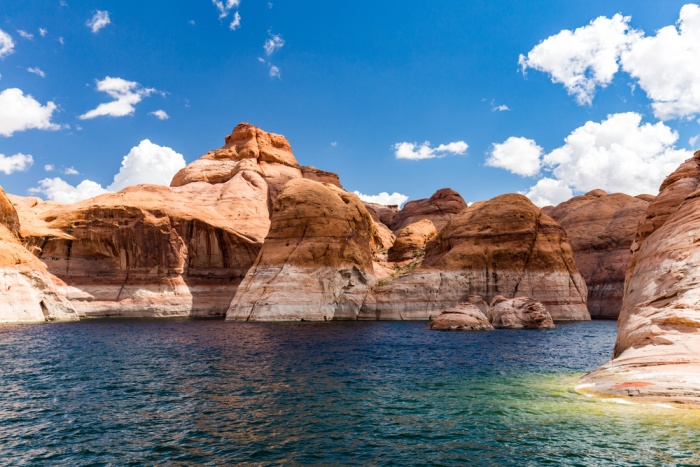
Copyright Images: Lake Powell Glen Canyon Depositphotos_98777336_S, Hoover Dam and Lake Mead Depositphotos_7914734_S











Do you have any knowledge about this water shortage affecting other countries around the world? What about the very close to me, Finger Lakes and Niagara Falls. I feel we all need to conserve all the resources we can.
Hi Chris, Finger Lakes and Niagara Falls, aren’t regions with any ongoing, systemic water or power crisis right now. What comes up is the normal pattern for both areas: occasional storm-driven power outages that utility crews restore within hours to a couple of days, not a lasting infrastructure failure.The one water-related item that surfaces is a mine leak issue at Cayuga Lake in the Finger Lakes, which is a local environmental/monitoring story rather than a water-supply outage. You have had outages due to weather related issues. We all must conserve water, its a fact of life. We take that faucet handle for granted. Clean water is critical to our survival. Linda
There are drought conditions all over the world. Certain SE Asian countries are stockpiling rice because of water shortages.
To see more look up the Hunga Tonga undersea Volcano and note other articles about the tectonic plates opening up with sea water going to the core of the Earth. Water comes back out between 500-750 degrees. Under pressure boiling is higher temp. Michael Chrichton, the author, said “of course there is climate change. The Earth used to be molton.” It also used to be frozen.
Hi CAddison, thank you for sharing about the Hunga Tonga undersea Volcano. Water is going to become very scarce. Linda
Linda,
It’s been really sad to see how the level of Lake Mead has dropped since Jane and I moved here in 2006. Guess we drink too much water, huh, 🙂
One water conservation effort all of us should make is to install drip or soaker hose irrigation systems for all gardens and landscaping that needs more water than rainfall alone can provide.
And here in the desert SW it isn’t just the lakes and Colorado River that concerns us. Our aquifers are being depleted faster than they can be recharged. The same is true of the plains States.
Hi Ray, you are so right about the aquifers. I know people who bought property with aquifers which are now totally dry after a few years. So much for thinking you will have water and it’s now dried up. We left Southern Utah to be closer to family. But, we could see the writing on the wall so to speak, that the city of St. George, Utah was exploding with overbuilt homes and high rises. I believe they cannot sustain the city and the outlying cities because of the water that is being used to put out fires but also the amount of people moving there. There is not enough water for Southern Utah. I expect the prices of the homes to go down if the water levels do not change. I could be wrong, but I don’t think so. Linda
We collect between 5-10 gallons of water daily from our a/c outfall.
On our island nobody waters lawns or much else. We have R/O water because all wells are brackish. It’s not cheap water! There was no running water out here until sometime in the 1960s. Many homes in the Bahamas have cisterns. Our last house here in florida had a cistern.
We survived on our sailboat in the Bahamas on 3 gallons of water/day. Our toilets flushed with salt.
I haven’t let water run to brush my teeth in 40+ years.
Of course the longest I’ve gone without a shower is 4 months. Between deep snow camping and the Bahamas, you learn how to conserve.
Hi CAddison, I so jealous of your life (in a good way-happy for you)! I love hearing how you survived on you sailboat using only 3 gallons of water a day. I’m glad you mentioned “I haven’t let water run to brush my teeth in 40+ years”. I do the same thing, I do not want to waste the water. Great reminder. Linda
Linda- this was one of your best posts. Time for people to wake up. In addition to the meager wheat crop this year, now I read that corn is in big trouble.
HI CAddison, thank you for your kind words. I grew up water skiing in Lake Mead and Lake Powell. I grew up in Las Vegas, Nevada. That doesn’t surprise me about corn, the problem with corn it’s not just corn on the cob so to speak. It’s much bigger as you know. Linda